
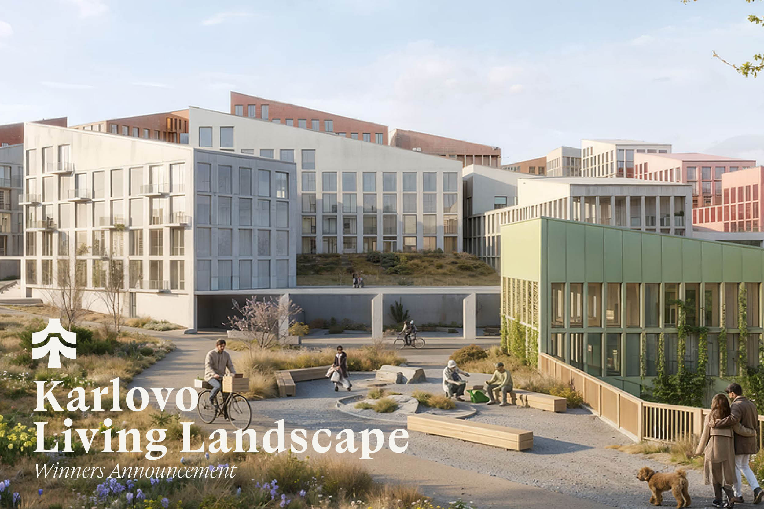
Terraviva has officially released the complete list of awarded projects of the architecture contest entitled “Karlovo Living Landscape”.
Set on the hillside of Banská Bystrica, the Competition invited designers to envision a new residential district capable of redefining the relationship between housing, nature and community life. The challenge called for a compact, low-rise neighbourhood that balances density with openness, sustainability with comfort and individuality with collective identity. Participants were encouraged to design a cohesive urban fabric where pedestrian paths, gardens and small plazas seamlessly connect buildings and landscape, fostering a continuous dialogue between indoor and outdoor living.
The awarded proposals were praised for their clarity, coherence and ability to translate conceptual ambition into well-resolved urban systems. The jury highlighted projects that demonstrated a strong understanding of spatial organization, successfully structuring blocks, circulation and open spaces into functional and visually compelling environments. Particular attention was given to the integration of landscape and green infrastructure, enhancing both environmental performance and quality of life. Some proposals stood out for their architectural consistency and identity, combining carefully articulated façade strategies with modular and feasible construction approaches. Others were recognized for their sensitivity to topography and their ability to create well-balanced relationships between buildings and shared spaces, as well as for progressively refining strong concepts into realistic and buildable masterplans.

Terraviva warmly congratulates all participants for their creativity and dedication, whose proposals have contributed to imagining new forms of living where architecture, landscape and community are deeply intertwined.
The winners were selected by an international jury panel composed by:
• Katarína Michalková [Bratislava, Slovakia] | BMX Studio
• Juan Lucas Young [Berlin, Germany] | Sauerbruch Hutton
• Martin Pavelek [Banská Bystrica, Slovakia] | SK Chambers of Architects
• Jan van Dijk [Dundalk, Ireland] | van Dijk Architects
• Maria Lucrezia De Marco [Milan, Italy] | Stefano Boeri Architetti
• Harrison Stallan [Rotterdam, Netherlands] | OMA
• Maria Virginia Theilig [Rosario, Argentina] | FAPyD
• Chao Li [New York, USA] | Snøhetta

Winner
Sásová Hills
Guzel Amirova, Anastasiia Grudeva
Kazakhstan


_________________________________________
About the First Prize – JAN VAN DIJK – van Dijk Architects
“The proposal represents a highly accomplished and well-resolved urban scheme, combining strong spatial quality with a clear and coherent development logic. The project demonstrates an excellent understanding of how to structure urban blocks, open spaces, and circulation in a way that is both functional and visually compelling.
The spatial quality of the scheme is particularly noteworthy, with generous open spaces, well-defined public realms, and a strong relationship between built form and landscape. The integration of green infrastructure is handled with confidence and clarity, contributing to both environmental performance and quality of life.
Architecturally, the proposal is outstanding. The façade strategy is carefully considered and clearly articulated, creating a strong and consistent identity while allowing for variation across the development. The use of modular systems and contemporary construction approaches further reinforces the scheme’s feasibility.
Overall, this is a confident, mature, and highly convincing proposal that successfully integrates design quality, technical thinking, and deliverability.”
About the First Prize – MARIA LUCREZIA DE MARCO – Stefano Boeri Architetti
“The project demonstrates a serious and professional approach in a consistent, thorough, and well-articulated manner.
In particular, the project shows a significant ability to combine a comprehensive masterplan vision—including aspects related to resource management and environmental sustainability—with a careful attention to architectural detail and everyday use.”
Finalist
Stratum
Uladzislau Chabai, Dzmitry Serhienya
Netherlands – Georgia


_________________________________________
About the Finalist – KATARÍNA MICHALKOVÁ – BMX STUDIO
“The project is awarded for its urban methodology, which integrates new layers into Codroipo’s existing fabric. By replacing rigid fences with vegetative filters and focusing on active mobility, the proposal transforms the district into a shared space where social inclusion and ecological resilience weave a new urban fabric. The strategic framework, built around two loop paths (North Sports Loop and South Nature Loop), reconciles local history with contemporary needs. The new sports hall, a light-filled structure, serves as an architectural hub and a new landmark for the community.”
Finalist
“Confluence” Neighbourhood
Aisylu Zaripova, Elina Timergalieva , Maria El Tabib
Russia – Lebanon


_________________________________________
About the Finalist – HARRISON STALLAN – OMA
“This proposal demonstrates a particularly strong evolution between phases, successfully advancing a clear conceptual framework into a more resolved and buildable system. The introduction of building typologies and floor plans significantly strengthens the project’s spatial clarity and feasibility.
The masterplan maintains its distinctive identity and strong landscape ambition, while increasingly addressing the practical requirements of implementation.
Overall, this is a confident and well-developed project that effectively balances conceptual ambition with growing technical resolution.”
Finalist
A Growing Neighborhood
Petra Ristic Abdou
Austria


_________________________________________
About the Finalist – KATARÍNA MICHALKOVÁ – BMX Studio
“The building proposal responds to the site’s sloping topography, reflects the zoning defined by the master plan, and sensitively proposes a mix of building types in connection with natural features.
A strong motif and a major asset of the scheme is its consistent approach to the existing mature greenery, treated as a lasting value of the site.”
Finalist
HEART OF MOUNTAIN
Serge Khudyakov, Nino Utiashvili, Elizaveta Ulanova, Anna Karneeva, Anastasia Ulyanovskaya
Russia – Spain


_________________________________________
About the Finalist – MARTIN PAVELEK – SK Chambers of Architects
“Well-thought-out, very efficient development in a rectangular grid makes maximum use of the potential of the area while maintaining the quality of housing.
Generously designed public space for civic amenities.
Simple architecture made of regular modules, the basic material used is wood.”
Golden Mention
The Living Colonnade
Taulant Haxhiu, Blina Rabi, Flor Haxhiu
Kosovo


Karlovo Living Landscape – The Living Colonnade
Located in the natural setting of Karlovo, the Living Landscape – The Living Colonnade project proposes a masterplan that harmonizes architecture with sloped terrain rather than imposing upon it. From the outset, the design is guided by one essential principle: to respect the land, preserve its natural density, and create a symbiotic relationship between architecture and the surrounding forest ecosystem.
Harmonizing with the Sloped Terrain
Instead of flattening the hillside through excavation, the building steps gently down the slope, adapting to the site’s natural contours. The footprint follows the terrain, allowing the structure to ascend and descend organically while minimizing earthworks.
A key achievement of this strategy is the preservation of approximately 65–70% of the existing trees. By carefully positioning the massing, the project safeguards mature vegetation and maintains the ecological richness of the area. The architecture settles within the forest rather than replacing it, protecting biodiversity, supporting microclimates, and reinforcing the identity of the site as a living landscape.
A Conscious Reduction of Volume
The competition guidelines outlined a potential total Gross Floor Area (GFA) of 123,491 m² and a Net Floor Area (NFA) of 86,443 m². However, analysis revealed that building to this capacity would overwhelm the terrain and reduce livability.
The proposal therefore limits development to 70,000 m² of GFA, producing approximately 49,000 m² of NFA- a reduction of 53,491 m² in GFA and 37,443 m² in NFA. This decision prioritizes environmental integrity and quality of life over density maximization.
Rather than dense monolithic blocks, the design introduces a fluid architectural ribbon that weaves through the landscape. This reduced volume prevents the “smothering” of the site and allows ground-floor retail, cafés, and childcare facilities to open directly onto community gardens, informal sports courts, and sunlit green areas. By building less, the project offers more open space, sunlight, and shared experiences
Modular Construction and Topographic Adaptation
The architectural system is based on a modular construction method that ensures clarity and adaptability.
- Topographic Adaptation
Portal frames of varying heights allow the structure to follow the slope naturally. By adjusting levels, the building steps along the hillside without heavy leveling, responding precisely to existing contours. - Roof as a Functional Module
The repeated structural system transforms the roof into an active surface. Solar louvers and photovoltaic panels are installed as standardized systems along the roofline. Where frame heights change, the roof of a lower module becomes a terrace for the adjacent higher module, maximizing outdoor space and creating layered communal platforms.
The residential floor plans are organized around a repetitive spatial module composed of a central circulation core and standardized apartment aggregation. Applied consistently across all residential blocks, this system ensures constructive efficiency, typological coherence, façade uniformity, and programmatic flexibility. The same logic extends throughout the PB 02 residential zone, with minor adaptations enabling transformation within the PZ 03 mixed-use zone. This repetition maintains architectural unity while allowing functional diversity.
Solar Strategy and Environmental Systems
Sustainability is embedded in the architectural form. A total of 645 solar panels are positioned along the southernmost curves of the roof to maximize exposure and avoid self-shading, integrating renewable technology with design.
Additional strategies include high-efficiency triple-glazed windows for daylight and insulation, reducing heating and cooling demands. A subterranean rainwater detention and treatment system collects runoff and recycles water for internal use. Green roof systems improve insulation, mitigate heat island effects, and promote biodiversity. Together, these measures enhance environmental performance and reduce energy consumption.
Community Green Roof Hub
A defining feature is the transformation of the rooftop into an active community space. The “Active Green Roof” converts unused roof surfaces into a multi-purpose Sky-Commons.
Community gardens with raised beds encourage residents to cultivate vegetables, herbs, and flowers. Recreation zones with shock-absorbing turf support yoga, casual sports, and play, while shaded pergolas and seating areas accommodate gatherings and events.
An open structural framework forms a sunlit “living room in the sky” with panoramic views. Quiet lawns and pathways support relaxation, while structural ribs enable outdoor gym equipment and recreational nets. Surrounding vegetation cools the building, improves air quality, and creates habitats for pollinators, strengthening environmental resilience and neighborhood cohesion.
Vegetation and Seasonal Strategy
The planting palette follows a phenological approach to ensure year-round interest. Selected species provide spring blossoms, summer greenery, autumn color, and winter structure. Preserving mature trees and introducing compatible new plantings strengthens biodiversity while maintaining the forest character of the site.
This seasonal strategy enhances both ecological continuity and everyday experience.
Urban and Architectural Compliance
The proposal aligns with regulatory requirements while preserving architectural consistency.
PB 02- Residential Low-Rise Zone
Regulations allow 2- 4 storeys above ground, with an optional recessed fifth floor occupying less than 50% of the footprint. The maximum built-up area is 60%, with a target DER (NIA/GFA) ≥ 0.80. The design adopts a four-storey configuration with a potential recessed fifth level, allocating roof areas to terraces and green spaces while ensuring sunlight and green continuity.
PZ 03 – Mixed-Use Zone Adaptation
This zone permits up to five storeys, 65% maximum coverage, active ground floors, upper-level housing or short-stay units, and integrated parking. The same modular system adapts seamlessly: ground floors accommodate retail and services with increased ceiling heights, while upper levels retain standardized residential layouts.
Conclusion: A Symbiotic Living Framework
The Living Colonnade demonstrates that environmental stewardship, regulatory compliance, and architectural clarity can coexist within a unified modular framework. By reducing built volume, preserving natural density, and stepping the structure along the terrain, the project achieves a balanced relationship between architecture and nature.
Rather than maximizing square meters, the masterplan maximizes quality of life. It integrates renewable energy, promotes biodiversity, creates layered communal spaces, and protects the forested identity of Karlovo, offering a sustainable, human-scaled neighborhood shaped by harmony rather than dominance.
Golden Mention
Nature Gateway
Sang Kim, Giheon Lee
South Korea


Nature Gateway
Context
Banská Bystrica is shaped by the close relationship between everyday life and a strong mountain horizon. The 53,105 m² competition site sits on a south-facing hillside at the western edge of Sásová, positioned between established housing and the foothills of the Low Tatras. This setting frames a clear ambition: a 21st-century neighbourhood where nature is not a boundary, but the organising structure of daily life.
Site Reading
The site falls from higher ground in the north to lower ground in the south, where the primary site access and a nearby bus stop provide public transport access. The northern edge meets more natural hillside vegetation, while the south-east ties into the neighbourhood street network. The proposal operates as a Nature Gateway, extending ecological continuity into Sásová while introducing a compact, human-scaled structure to the vacant edge condition.
Organising Framework
A simple grid establishes coherence, clear addresses, and phasing logic, but it is interpreted first as a pedestrian and landscape framework. Two axes define identity and movement. A north–south nature axis draws the forest condition deep into the site, while an east–west neighbourhood axis extends the surrounding street network into the site, strengthening connectivity and defining a more active mixed-use edge.
Meandering Passage
The hillside demands an adjustment beyond the grid, and the meandering passage cuts decisively through it, becoming the primary organiser of movement and built form. It follows ridge lines and contour logic to maintain gentle gradients with frequent level landings, improving walkability beyond an orthogonal system. It becomes the primary public room of the district, stitching wilderness to civic arrival through a continuous sequence of courtyards, gardens, and shared terraces where movement, landscape, and social life operate as one system.
Public Space Gradient
Public space is organised along the passage, shifting from passive to active. In the quieter northern and central stretches, it expands into everyday communal settings such as an outdoor amphitheatre, community gardens, daycare, and playgrounds. Toward the southern edge, where access is most direct, the sequence intensifies into civic spaces including a plaza, square, viewing deck, and sports amenities, anchored by the water landscape.
Water-Positive Landscape
The landscape strategy follows the site’s natural fall from north to south. Permeable surfaces, planted swales, and retention gardens slow and filter runoff, supported where required by subsurface drainage layers that direct overflow to the lowest point. Here, a retention pond operates as both infrastructure and civic foreground, improving water quality, supporting habitat, and supporting groundwater recharge, while creating a climatic and social focus. Green roofs and roof terraces extend planted surfaces upward, reduce heat gain, and reinforce a continuous ecological network by minimising sealed ground for long-term durability and low maintenance.
Architecture and Typologies
Massing and typology are guided by sunlight, privacy, and the mountain context. Residential blocks combine compact courtyard blocks and terraced forms stepping with the slope. Varied pitched rooflines preserve view corridors, reduce mutual obstruction, and shape a village-scale skyline that echoes the mountain profile. The commercial block faces east and steps down with the terrain to sustain an active street edge without compromising daylight and views for the housing behind, extending landscape through planted roofs and terraces while supporting neighbourhood-scale daily services. The civic building is lifted to keep the ground plane open and continuous, allowing the main pedestrian route to pass through a shaded undercroft. Its roof becomes an elevated public terrace, and its section works like a bridge that maintains the Nature Gateway continuity while framing the retention pond as a civic foreground.
Mobility
Mobility is structured as a hierarchy that prioritises pedestrians and cyclists while keeping internal public space car-light to protect landscape continuity. Vehicular access follows the planned street connections, with parking consolidated underground or beneath podium conditions to minimise surface disruption and preserve a porous green structure. The proposal targets capacity for approximately 900 cars in consolidated facilities aligned with access corridors, supporting clear wayfinding and phasing flexibility. Around 1,000 bicycle spaces are distributed close to entrances and lobbies for safety and daily convenience, reinforcing links to sidewalks, cycle routes, and nearby public transport.
Phasing
The masterplan is structured in three clear phases to keep delivery realistic while protecting the project’s core idea. Each phase completes a functional neighbourhood unit with legible access, essential open space, and a continuous portion of the Nature Gateway spine, so walkability and landscape continuity are established early rather than deferred. Phase 1 delivers the initial residential cluster, including the commercial block on the east and the first Nature Gateway segment. Phase 2 completes the main housing fabric and courtyard network. Phase 3 adds the civic and mixed-use components, together with the pond-anchored public realm, to complete the district. The grid supports incremental build-out, while the meandering passage acts as the constant public armature that connects phases into one coherent neighbourhood.
Conclusion
Nature Gateway proposes a district where the architecture of everyday life and the hillside’s living systems are designed as a single system. By stepping with topography, preserving sunlight and view corridors, and using the meandering passage as a continuous public room from forest edge to civic plaza, the masterplan balances compact density with generous open space, and privacy with community. Water management is integrated as civic landscape through a water-positive landscape strategy anchored by the retention pond, reinforcing biodiversity, comfort, and long-term resilience. The result is a coherent, car-light, low-maintenance neighbourhood model rooted in the mountain identity of Banská Bystrica.
Golden Mention
Valley Commons
Ana Castellano Vidalle
Argentina


VALLEY COMMONS
topography as urban ground
Valley Commons proposes a landscape-driven residential and civic development in Banská Bystrica in which topography becomes the primary urban ground for ecological performance, collective life and spatial continuity. The site’s natural slope is understood as an active spatial framework capable of structuring movement, public space and programmatic relationships across the valley landscape.
The proposal is organised around the introduction of a constructed hydrological valley carved into the existing terrain. This new landform operates simultaneously as a stormwater management system, a continuous public open space and a pedestrian circulation spine. Conceived as a blue–green infrastructure, the valley performs as the ecological and spatial backbone of the masterplan, structuring visual connections, circulation routes and programmatic distribution throughout the site. In doing so, the sloped terrain becomes an inhabited civic landscape where environmental performance and social interaction are embedded within the same spatial system.
Residential volumes are arranged in stepped configurations that follow the site’s natural gradient. This terraced organisation minimises ground intervention while enabling each dwelling to maintain visual continuity with the surrounding landscape. The buildings’ ground floors are conceived as permeable thresholds that allow circulation to pass through or alongside the residential fabric. This permeability establishes a network of walkable passages that reconnect previously fragmented pedestrian routes and integrate the development into the wider urban context.
At ground level, the hydrological valley becomes a sequence of differentiated spatial conditions ranging from planted wetlands and retention basins to accessible decks and pedestrian crossings. These landscape elements support informal recreation, slow mobility and everyday social interaction while maintaining the environmental performance of the water system. In this way, the landscape operates as civic infrastructure that structures daily life and movement across the development.
Private outdoor spaces for ground-floor residential units are integrated through floating timber platforms positioned at the edge of the central pond. These decks act as extensions for apartments without access to conventional private gardens, allowing residents to establish a direct spatial and visual relationship with the water landscape while preserving the continuity of the public ground plane. Gradients of privacy are introduced through spatial transitions between public walkways, shared edges and private terraces.
A compact community centre is positioned along the valley as an anchoring civic element within the masterplan. Its built form encloses internal planted courtyards that extend the landscape into the architectural volume, reinforcing continuity between terrain and enclosure. Adjacent to this programme, a linear commercial street is integrated within the ground-level circulation network as a pedestrian-only environment. Cafés, local retail and shared amenities activate the interface between residential and civic functions, supporting neighbourhood interaction throughout the day and contributing to an active public frontage along the landscape spine.
Vehicular movement is restricted to the site perimeter, while parking is accommodated within basement levels distributed across the development. This car-light strategy allows the ground plane to remain predominantly pedestrian, enabling safe and continuous walking and cycling routes that connect internal public spaces with public transport links located to the south of the site.
Architecturally, the residential buildings adopt a recessed glassline that generates shaded balconies oriented towards the valley landscape. This façade strategy enhances environmental performance while framing outward views towards the central landscape. On opposing elevations, more compact openings respond to privacy requirements and adjacency to neighbouring plots. Exposed concrete volumes are complemented by timber elements and integrated vegetation, establishing a restrained architectural language grounded in durability and contextual continuity.
The development is structured through a phased implementation strategy that aligns landscape formation with programmatic delivery. An initial phase establishes the civic centre together with the central water landscape as an active public core. Subsequent phases consolidate the commercial frontage and complete the residential fabric in coordination with the broader landscape network.
Through the integration of water systems, pedestrian movement and public space within a shared topographic framework, Valley Commons establishes a contemporary model of housing in which architecture emerges from the shaping of the urban ground. The resulting environment operates as a continuous inhabited landscape that supports ecological resilience, collective accessibility and long-term spatial adaptability.
Golden Mention
Of Fuel & Forest
Timothy Simons
Netherlands


Of Fuel & Forest
The project begins not with buildings, but with the hill itself. The site is understood as a living terrain shaped by water, forestry, and agricultural use, positioned between settlement and landscape rather than belonging fully to either. Instead of imposing a new order, the proposal reads the hillside as an active system whose logic already exists: water flows downward, vegetation gathers along edges, and habitation settles where ground becomes negotiable. The masterplan grows from this understanding, allowing landscape to lead and architecture to follow.
The title Of Fuel & Forest reflects the site’s productive history, where woodland once functioned as material and energy source connecting nature and settlement. This legacy is translated into contemporary spatial elements rather than preserved as nostalgia. A series of contemporary artifacts, namely corten steel water rills, thresholds, and infrastructural markers, make hidden systems visible, allowing water, material, and memory to become part of everyday experience.
The neighbourhood is organised as a gradient between formality and naturalness. A structured civic core concentrates earthwork, shared infrastructure, parking, and collective programmes where intervention is unavoidable. Here, water management appears in its most legible form, shaping public space and revealing how the hill performs environmentally. Moving outward, the structure loosens as buildings respond to contours, vegetation, and ecological rhythms. Architecture becomes quieter, embedded within landscape rather than dominating it.
Three interconnected paths express different readings of one integrated system. Walking with Nature follows the softer landscape edge, where water infiltrates through swales and forest soils and ecological elements invite direct engagement with biodiversity. Walking with Memory, the civic spine, combines social life and infrastructure, where water flows through corten rills alongside playgrounds, outdoor dining, small-scale agriculture, and collective spaces. Walking with Innovation climbs the hillside through stepped landscape interventions that demonstrate how habitation and topography can coexist.
Water acts as the project’s primary driver. Rain is buffered on roofs, absorbed by planted landscapes, guided through civic rills, stored in intermediate basins, and ultimately collected in a new retention lake, ensuring water is slowed, filtered, and experienced before leaving the site.
Compact buildings step with the terrain, anchored by concrete plinths and finished in locally sourced larch timber that weathers into the landscape. Phasing begins with the civic core and parking, followed by urban-facing blocks, and concludes with quieter forest housing. By allowing landscape systems to guide development, the proposal adopts a reduced density of approximately 45,000–50,000 m², prioritising ecological performance and long-term livability.
Rather than separating city and nature, the project proposes a symbiotic condition where landscape, infrastructure, and community form one continuous living system.
Golden Mention
The Inhabited Forest
Juan Camilo Bonilla Herrera, Laura Liliana Rubiano Camacho
Argentina – Colombia


This project proposes the creation of a soft threshold between the urban fabric and the forest density, understood not as a rigid boundary but as a lived landscape where architecture, flora, fauna, and community coexist in balance. Located in the city of Banská Bystrica, Slovakia, along the strategic edge of the Šastovská nature reserve, the site contains mature trees, established vegetation, and wildlife that reflect an ecosystem in its purest state. Rather than imposing an architectural object, the proposal seeks to integrate itself as another element of the environment, acting as a gentle introduction to the forest and a gradual transition between the accelerated rhythm of urban life and the protective silence of the natural landscape.
The intervention emerges from a reflection on the relationship between construction and territory within a context of global environmental urgency. If architecture has historically contributed to the fragmentation of ecosystems, this project proposes the opposite approach: to restore, regenerate, and coexist. The building is conceived as a living system, connected to water cycles, soil dynamics, and human activity, where respect for biotic agents shapes every design decision.
Within this framework, the proposal places special attention on older adults, recognizing that aging requires spaces that are gentle, predictable, and free of obstacles. The project rejects functional segregation and instead incorporates reduced mobility as the guiding metric for the entire volumetry and circulation. For this reason, the intervention is organized through a system of gentle ramps that ensure true universal accessibility. These circulations are not merely logistical connectors but kinetic viewpoints that allow inhabitants to experience changes in topography fluidly, ensuring that the landscape is accessible to everyone regardless of age or physical ability.
The central concept is rooted in ecological regeneration and the coexistence of species. The project functions as an “inhabited forest,” where the limit between natural and built becomes blurred through rain gardens, guided water bodies, and biochannels that structure the landscape. These systems allow water to be absorbed, filtered, and returned to the soil, replicating the hydrological processes of the surrounding forest. Beyond their environmental importance for stormwater management, these infrastructures also create a sensory experience that uses sound and humidity as atmospheric design tools.
Vegetation becomes the true structure of the project. Existing pines, firs, and larches are preserved rigorously, maintaining the ecological memory of the site and its carbon-capture capacity. Local species such as Acer rubrum, Fagus sylvatica, and Sorbus aucuparia are incorporated, bringing seasonal chromatic variation that adds poetic temporality to the ensemble. The lower layers include a functional understory with shrubs such as Hydrangea paniculata, Spiraea nipponica, and Berberis atropurpurea, providing refuge for small fauna and pollinators. In humid zones, species like Carex acuta, Iris sibirica, and Juncus effusus act as biological filters along the edges of the biochannels. This selection helps regulate the microclimate, stabilize the soil, and maintain habitat continuity for birds and insects—considered legitimate cohabitants of the project.
The architectural program integrates living, learning, and caregiving within a continuous spatial fabric that dissolves the hierarchy between public and private. Housing is organized into flexible typologies ranging from one to four bedrooms, responding to diverse family structures and preventing generational segregation. All buildings are connected by ramps, eliminating physical barriers throughout daily circulation. Community spaces—including a contemplative garden, a productive orchard, a pedagogical greenhouse, a library, and a center for older adults—promote intergenerational interaction linked to the cycles of the land. The project also incorporates a bicycle center, environmental interpretation points, and nodes for ecotourism guides, reinforcing the bond between the local community and the Šastovská reserve. These infrastructures encourage a slow and mindful relationship with the territory, turning residents into guardians of the ecosystem.
Materially, the proposal seeks the visual dissolution of the built object to give prominence to the context. Locally sourced wood is used as the main façade material, employing vertical grain patterns that evoke the texture of tree trunks and allow the architecture to blend with the forest through shifting shadows and reflections. The intention is not to create a dominant gesture or iconic object but a serene presence that respects the scale and rhythm of the landscape. The volumes are fragmented to integrate with the topography and vegetation, creating a play of solids and voids similar to the canopy of trees, where sunlight filters gently into the interior. With time, vegetation on balconies, terraces, and roofs will allow the architecture to be reclaimed by nature, behaving more like a living organism than a static object and enhancing the integration of the ensemble through the patina of time.
Above all, this project is a reflection on time, resilience, and the ethical responsibility of architects toward the territory. It is conceived not as a finished intervention but as an open system capable of growing and transforming alongside the landscape. Vegetal regeneration, water cycles, and community life will progressively shape the identity of the place, allowing it to evolve naturally toward ecological maturity. The architecture merely establishes the initial conditions, while nature completes the final construction process.
In essence, the proposal envisions a new way of inhabiting—one based on a symbiotic relationship between humans, animals, and landscape, where birds, insects, and native vegetation are essential components of the system. The project becomes a “soft passage” between city and forest: a space of deceleration where calm, respect, and ecological awareness emerge. Rather than standing out from the landscape, it aims to belong to it as a living fragment, where architecture and nature intertwine so that the landscape is not only observed but lived in all its complexity and beauty.
Golden Mention
Sponge Village Karlovo
Patryk Wlodarczyk
Poland


SPONGE VILLAGE KARLOVO
Proposed residential complex has been designed as a contemporary interpretation of a foothill settlement, harmoniously integrated into the landscape of Karlovo and its natural topographic conditions. The project uses the sloping terrain as one of the key compositional elements shaping both the urban structure and the character of public spaces. Varied building heights allow the development to blend smoothly into the hillside, minimizing landscape intervention while ensuring all residents have access to daylight, views, and greenery.
The buildings are arranged in terraces following the natural slope of the land, enabling a clear division into smaller residential clusters connected by a network of pedestrian routes and shared green spaces. This layout fosters the creation of intimate, semi-private courtyards that function as local neighborhood centers. Each serves as a place for meetings, relaxation, and everyday activity, strengthening social ties and a sense of belonging.
The urban structure derives from an analysis of classical city blocks. Instead of closed perimeter blocks, their reinterpretation is proposed-open, permeable blocks that interweave with the landscape. This results in a “soft block” structure that maintains a clear street frontage and sense of urban enclosure while introducing openings, passages, and visual connections to greenery. The layout loosely follows the slope, adapting to natural land contours rather than leveling them. As a result, the development avoids rigid grids and organically fits into the topography, giving
inter-building spaces a dynamic, sequential character.
The urban concept also references the structure of historic streets in Banská Bystrica, which often lead from narrow, intimate spaces to open squares. In Karlovo Living, this motif is transformed into a sequence of green passages and landscape plazas. Narrow pedestrian paths gradually expand into shared spaces-green courtyards, rain gardens, and recreational clearings. This creates a clear spatial hierarchy from private, through semi-private, to fully public. Each block includes a main building with a green rooftop terrace dedicated to collective neighborhood gardening, fostering community integration.
Pedestrian and bicycle movement is given clear priority throughout the development, with a carefully designed network of safe, comfortable, and accessible routes encouraging active and sustainable mobility. Vehicular traffic is limited mainly to the main access street and four underground parking facilities, which reduces surface traffic, minimizes noise and air pollution, and enhances the quality of public spaces. This approach creates a calm, people-oriented environment that promotes everyday walking and cycling while maintaining efficient access for residents and services.
The architecture of the complex is based on the idea of contemporary regionalism. Wooden façades, simple volumes, and gabled roofs reinterpret traditional architecture through the language of modern, energy-efficient design. The use of local materials, natural textures, and muted colors allows the buildings to blend into the landscape and maintain cultural continuity. Rather than dominating their surroundings, the buildings form a calm, harmonious backdrop for everyday life.
One of the project’s key principles is the implementation of the Sponge City concept-a city capable of retaining, purifying, and gradually releasing rainwater into the environment. The water management system is based on blue-green infrastructure solutions, including rain gardens, infiltration basins, retention tanks, permeable surfaces, and ponds. Rainwater is not discharged directly into the sewage system but remains within the development, nourishing vegetation, improving the microclimate, and reducing flood risk.
Green areas feature extensive vegetation adapted to local climatic conditions and requiring minimal maintenance. Flower meadows, grasses, and perennials enhance biodiversity and act as natural filters for rainwater. Centrally located water reservoirs and ponds serve both retention and recreational functions, creating visually attractive landscape elements.
Usable rooftops are another important component of the concept. Collective gardens accessible to residents are designed on the flat roofs of residential clusters. They function as shared recreational spaces, places for cultivation, social interaction, and relaxation. Rooftop gardens strengthen the local ecosystem, improve building insulation, and form an additional layer of water retention. Each housing cluster has its own garden space, supporting the formation of local communities.
The lower part of the site is designed as a recreational and service zone. It includes sports facilities, leisure areas, and everyday amenities such as cafés, small retail units, and coworking spaces. This part of the development functions as an open, accessible center connecting residents with the broader urban context.
Karlovo Living forms a coherent, sustainable organism in which architecture, landscape, and environmental infrastructure complement one another. The project combines local identity with modern ecological solutions, creating a climate-resilient neighborhood that promotes social integration and a high quality of life. It is a place where daily life unfolds in harmony with nature, and environmental responsibility becomes an integral part of the architectural narrative.
Golden Mention
TERRACE VIVA: Karlovo Living Landscape
Petra Sitárová, Katarína Holicová, Vanessa Rýsová
Slovakia


Karlovo_Strada Terazzada
Genius Loci and Historical Narrative The Karlovo locality, named after the prominent Karlov family who owned these lands north of Banská Bystrica’s historic core as early as the 14th century, represents a vital developmental axis. Our urban proposal does not introduce a foreign element; it is a reinterpretation of the landscape’s historical intelligence. The original agricultural fields, arranged perpendicular to the slopes, and the lines of hedgerows that protected the soil from erosion, become our primary compositional grid. The project thus seamlessly continues the transformation of the area from an agricultural periphery into an integrated and sustainable urban district.
Massing and Porosity The fundamental goal of the urban solution was to avoid creating visual or physical barriers on the exposed slope. We propose a hybrid structure—a combination of point and sectional apartment buildings grouped into open blocks. This fragmentation of volumes ensures a high degree of porosity, maximizing southern views of the city skyline and the surrounding mountains. The gaps between buildings are filled with greenery, allowing for natural airflow from the Panský Diel massif and passive cooling of the district.
Three Sectors: From Urban Dynamics to Park Serenity The territory is functionally graded into three sectors. The upper residential area (4.5 floors) serves as an oasis of quiet living. The middle zone defines the “Urban Corso” with mixed-use functions (5.5 floors). The Corso is situated exactly along the path of the existing trail leading to the Sásová Valley. Here, we propose an active ground floor with a bakery, local shop and a “pick-up hub” to serve Karlovo residents and the wider neighborhood. The third sector, located in a natural terrain depression (the “Pit”), is transformed into a central public park. The architecture here is smaller in scale and pavilion-like (up to 2.5 floors)—a community center, a kindergarten, a senior living community, and a restaurant are sensitively embedded in the greenery, creating a safe, socially inclusive environment.
Technical Infrastructure and Mobility The transport solution combines competition requirements with the logic of the terrain. While respecting the planned road from the south, we add a second service branch that passes through a newly designed hedgerow. This road follows the contour line, efficiently serving the area without drastic terrain cuts. The key element of pedestrian mobility is the “connection.” By aligning blocks along the contours, residents can connect to the Urban Corso almost barrier-free. The main link remains a pedestrian footbridge, which safely leads passers-by from the heart of the development to the lower green buffer and bus stop. Cars “disappear” into semi-recessed garages built in split-levels, allowing residents “dry-foot” access to their apartments directly from their parking spots.
Blue-Green Infrastructure as a Priority Water is a visible and form-giving element. We uncover original streams and trace them through the park zone. The historical system of irrigation ditches is transformed into a modern network of rain gardens and retention corridors. The hedgerows, perforated by pedestrian paths, function as biological filters and bio-corridors. Karlovo Living Landscape is not just a development; it is a living ecosystem where modern architecture bows to the logic of nature.
Golden Mention
Living flow
Katarína Fejo, Tomáš Hanáček, Nikoleta Mitríková, Róbert Lipták, Zuzana Kačírek, Roland Búš, Slavomír Černický, Ján Urban, Simona Hasprová, Ema Hečková
Slovakia


L I V I N G F L O W
- Structure follows morphology
Urban composition responds sensitively to the site’s natural topography, adopting terraced or stepped configurations. The slope is understood as an opportunity for views, diversity, and human scale. Diagonal connection with the Sásová and Sásovská dolina Recreation Area. Built-up platforms /60×15 m/ follow the slope and orientation of the terrain. The level connection between Ecopap Urban structure and BSB- Sásovská cesta represents the framework of future development. The diagonal connection between the Kostiviarska railway station, Sásová and the Sásovská dolina Recreation Zone connects different terrain levels. Buildings are oriented towards the south and south-west to maximise natural light and penetration of vegetation and microclimatic flow.
- New urban gateway
Implementation the Green Axes Model by focusing on pedestrian-friendly design, environmental infrastructure and the creation of green urban spaces. The promenade into nature connects different levels in the site. Continuous green network of courtyards, paths and squares prefers walking as an ecological mobility approach. Main goal is to stabilise and rehabilitate the informal network of paths and shelters. Traverse diagonal pedestrian movement for barrier-free access follows the tourist routes from outlook on the hill to swamp bank. Redesigning of the swamp for free public access with wooden deck for recreation and events, enhancing the district with green infrastructure and local amenities. Longitudinal path connects the site with Sásová village and potential development areas / Ecopap & BSB-Sásovská cesta/ everything on the same level. Pedestrian bridges connect different levels of public space in a barrier-free manner, offering extraordinary views and walks in the treetops.
- Living systems of nature
Green tissue grows from the surrounding natural environment in varying intensity. Soft urbanism approach supports biodiversity and sustainable water management. Water management integrate natural retention ponds, rain gardens and permeable surfaces. Proposal respects existing wetland with local swamp to ensure natural water retention & slow infiltration. Front gardens and growing terraces are designed as a continuity of the Stará Sásová Gardening Area. The main goal is to increase resilience to climate change and create new recreational opportunities for locals and tourists. The reforestation strategy included the use of “nurse plants”, fast-growing species that provide shade and protection and improve soil conditions. Preserve the existing invasive and ruderal vegetation, which provided key ecosystem services to the city. We choose the species composition of vegetation
with regard to the position in relation to the retained water, slope conditions and functional use.
- Cohesive neigbourhood
Compact, low-rise neighbourhood with a smooth transition into nature. United flowing forms with separate volumes for attractive interspaces. Southwest orientation illuminates the apartments. Various building volumes set naturally into the terrain. The height and functional diversity of the house typology follow the regulation limits of Urban Zoning Plan:
PO 01 / Civic Area / facilities as the kindergarten, fitness centre, restaurant or senior house
PB 02 / Residential Zone / Only apartment buildings with four above-ground floors
PZ 03 / Mixed-use Zone / Apartments with public ground floor / shops, cafés, bakery, pharmacy
- Community nooks
The future residents will primarily be families with children, seniors, or young couples.
“A good place to live” means to build places for “good neighbours”. Community nooks are suitable for open-air gym circuits, mini basketball courts, chess tables, kid’s playgrounds, pic-nic tables with vegetable gardens. These shared spaces are designed in different sizes, positions and with different activities for experiencing.
- Connective tissue
This area has potential to strengthen the city’s connection to its surrounding ecosystem.
Public spaces are designed as open spaces for diverse social life. Small squares and nooks offer shady spaces for locals and visitors to stay. These spaces provide recreational features with the creation of numerous resting and walking activities, including a children’s playground, relaxation platforms, wooden decks, Italian stairs, or community gardens. Two footbridges provide barrier-free connections to overcome the local gullies. The landscape design follows the principles of permaculture and cultivated wilderness, preserving its wild nature and ensuring an open, inclusive and environmentally- conscious design.
Golden Mention
Dwelling the Flowing Slope
Wentao Lyu, Zuohao Qiu, Tianwu Zheng
China


The proposal is grounded in the site’s vernacular architectural language and its exceptional landscape setting. Local precedents suggest a productive duality: linear collective housing that defines the street edge, and dispersed pitched-roof settlements that inhabit the hillside and woodland. Rather than replicating historic forms literally, the design translates this spatial logic into a contemporary framework—staging a dialogue between the civic and the intimate, the linear and the porous—while reinforcing a legible community structure.
A clear development hierarchy organizes the masterplan. Building intensity is highest along the urban road, where public programs and street-facing commercial uses activate the frontage and establish an address for the neighborhood. From this edge, the intensity gradually decreases toward the hilltop and into the forest interior, allowing architecture to become lighter, more fragmented, and more embedded within the terrain. This gradient not only responds to views, sunlight, and privacy, but also clarifies a sequence of public-to-private transitions across the site.
Two complementary housing typologies operationalize this strategy. Bar-shaped residential blocks front the primary street and act as organizing spines, partitioning the site into coherent bands. Their street-facing façades step back in a series of terraces to reduce perceived massing and relieve compression along the linear circulation corridor. These setbacks consolidate shared outdoor space vertically, culminating in accessible roof gardens that extend everyday life upward and soften the skyline. In contrast, point-block housing adopts a two-units-per-core configuration and is selectively distributed higher on the slope and among existing trees. The resulting micro-clusters form smaller, more enclosed communities with heightened privacy and a stronger relationship to landscape “rooms” rather than to the street.
A consistent material logic binds these different expressions. All buildings are anchored by a masonry plinth, establishing a robust, ground-hugging base that resonates with local construction traditions. Above, predominantly timber superstructures lighten the volumes and allow the architecture to age gracefully over time, developing a controlled patina that reinforces a tactile, time-worn character. Steel is introduced selectively—primarily within circulation elements such as ramps, connectors, and elevated walks—where slender spans, durability, and precision detailing are required.
Given the site’s abundant rainfall, water is treated as both resource and spatial generator. A rainwater harvesting network captures runoff from roofs and hardscape, reducing potable water demand and enabling reuse. Conveyance is made legible through a sequence of surface channels, dry-creek landscapes, and terminating landscape nodes, transforming stormwater management into an experiential ecological narrative. Water-based spaces are interwoven with the pedestrian realm, ensuring that hydrological processes are not hidden infrastructure but visible, inhabitable public amenities.
Finally, a continuous slow-mobility system stitches together the plan’s spatial partitions. A linear promenade mediates between street-front retail and the bar buildings, supporting everyday strolling and social exchange. Beyond, ramps, access alleys, woodland boardwalks, and intimate paths thread through the point-block clusters, aligning movement with terrain and water to choreograph a gradual shift from open commons to private gardens. Together, vernacular-informed typologies, a calibrated development gradient, and integrated water-and-walk networks form a coherent, resilient neighborhood framework—simultaneously contemporary in performance and rooted in place.
Golden Mention
KRAJINA DOMOVA – LANDSCAPE OF HOME
Juan David Botello, Marc Laibacher
Colombia – Germany


krajina domova – landscape of home
Housing in the Landscape of Karlovo proposes a housing structure that generates both home and community through its deep integration into the existing topography. Rather than imposing an external urban order, the linear building volumes follow the natural contours of the terrain, embedding themselves into the landscape. This strategy allows architecture and ground to form a continuous spatial relationship, where built form emerges from the site itself. The rhythm of the elongated housing bars is articulated by slender vertical towers that function as circulation cores and structural anchors. These elements not only organize access but also give identity and scale to the ensemble, creating a sequence of vertical accents within the horizontal settlement.
The project draws inspiration from the cultural heritage of Slovak longhouse villages and traditional street villages, where settlement patterns are closely tied to landscape logic and collective living. Instead of replicating historical forms, the proposal reinterprets their spatial principles in a contemporary architectural language. The result is a structure rooted in local identity while responding to current housing demands.
Constructively, the project is based on a hybrid timber–concrete system. The concrete base and vertical cores provide structural stability, fire protection, and long-term durability. Between these solid elements, prefabricated timber frame modules are inserted, forming the primary residential units. This hybrid approach combines the permanence of concrete with the flexibility and sustainability of timber construction. The modular timber units allow for internal reconfiguration and future transformation, ensuring adaptability over time.
The housing concept is intentionally open-ended. The structural grid anticipates the possibility of vertical extensions, allowing additional units to be built in response to future housing needs. Rooftop gardens with sun-shading structures create collective outdoor spaces while also serving as a reserve capacity for densification. In this way, the project does not define a final state but offers a spatial framework capable of evolution.
Central to the concept are the shared spaces between the buildings. These interstitial zones form the social heart of the settlement, hosting community gardens, informal meeting areas, and productive landscapes. Urban gardening enables residents to cultivate food collectively, strengthening social cohesion and resilience. The architecture acts as an infrastructural offer: it provides the structural foundation, while the inhabitants shape its appropriation over time. Housing in Karlovo is therefore not conceived as a fixed object, but as a living framework—embedded in landscape, rooted in cultural memory, and open to transformation.
SHORTLISTED PROJECTS

The post Results: Karlovo Living Landscape appeared first on Competitions.archi.